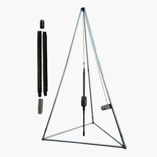
The ground conditions in Glasgow shift dramatically depending on which side of the M8 you're working on. Up towards Bishopbriggs, you're likely hitting stiff glacial till within a few metres—decent bearing material, but tough on sampling gear. Down near Govan or the SEC Centre, it's a different story entirely: deep alluvial sands and silts from the Clyde Valley, often with groundwater at shallow depth. That's where the Standard Penetration Test (SPT) becomes essential reading. It tells us the N-value profile foot by foot, flagging loose zones and dense layers before you commit to a piling strategy. For a Victorian tenement retrofit in Partick or a steel-frame distribution hub in Hillington, we combine SPT data with local geological memory—like knowing where the buried Drumlin tails pinch the drift to less than 2 m—so you're not paying for over-conservative assumptions. When the site investigation calls for deeper stratigraphy, we pair the SPT with cone penetration testing to get continuous resistance profiles without losing the sample recovery SPT provides.
SPT N-values in Glasgow's glacial till can swing from 8 to 50 within two metres of depth—interpreting that transition correctly is what prevents over-design.
Process and scope
One mistake we see repeatedly from contractors new to the West of Scotland is assuming that a single borehole log from the corner of the plot represents the whole site. Glasgow's drift geology doesn't work like that. A pocket of laminated silty clay left by a retreating ice lobe can sit twenty metres from dense sandy till, and if your SPT spacing misses it, the foundation design is compromised before the first digger arrives.
Our testing follows BS 5930:2015 procedures, with split-spoon samplers driven by a calibrated automatic trip hammer. We record N-values every metre in granular soils and at every change of strata in cohesive materials. The data flows straight into a factual report that includes depth, SPT N, soil description, groundwater observations, and sample recovery percentages. For a project in the Clyde Gateway area where contamination is a secondary concern, we coordinate the sampling sequence so that environmental grab samples are taken from the same split spoon, reducing mobilisation costs.
A proper SPT campaign in Glasgow isn't just about numbers—it's about interpreting those numbers against the regional stratigraphy. A blow count of 12 in the Paisley Clay member means something very different from N=12 in the Bellshill Sand. Our team has logged enough metres across the city to make that distinction instantly, which speeds up the geotechnical model and keeps your programme on track.
Site-specific factors
Glasgow sits on a complex patchwork of glacial and post-glacial deposits, and the Coal Measures bedrock beneath parts of the East End brings its own set of challenges—shallow mine workings are still being encountered on sites near Shettleston and Carntyne. Running an SPT programme without accounting for this legacy can leave voids undetected, and a sudden drop in blow count at depth is sometimes the first indication that you're drilling into a collapsed stope.
The risk isn't just geological. The Clyde's tidal influence pushes groundwater up through granular layers, and a standard SPT performed without casing in loose saturated sand near the river can underestimate density due to boiling at the base of the hole. We've seen N-values artificially depressed by 30-40% in these conditions, which leads to oversized foundations if the data is taken at face value. Our drillers are trained to recognise these conditions and adjust the method—adding water to maintain head, casing through unstable zones, and flagging any reading that might be non-representative. When coal mine risk is identified, the borehole is logged for void evidence and the SPT data is cross-referenced with the Coal Authority's mining reports for the exact postcode sector.
Questions and answers
How much does an SPT borehole typically cost in Glasgow?
For a single SPT borehole in the Glasgow area, you're looking at roughly £400 to £560 for a 10-metre depth, including mobilisation within the G postcode, the factual report, and standard laboratory classification on selected samples. Deeper boreholes or sites with difficult access—like backcourt tenement gardens where a hand-portable rig is needed—will push towards the upper end. We quote fixed-price per borehole once we've seen the site layout.
What's the difference between SPT and CPT for a Glasgow site?
SPT recovers a disturbed soil sample in the split spoon, so you get a visual description and can run index tests—which matters when you're dealing with the variable tills around Glasgow. CPT gives you a continuous resistance profile and is faster in soft clays, but it doesn't produce a sample. On mixed-strata sites near the Clyde, we often recommend starting with SPT to log the sequence, then using CPT for targeted profiling of the soft layers.
How many SPT boreholes do I need for a residential extension in Glasgow?
For a single-storey extension on a standard tenement plot, two boreholes to 6-8 metres depth usually satisfy Building Control requirements, provided they're positioned to capture any variation across the footprint. If the garden shows signs of historical filling or the property is within a Coal Authority high-risk area, we'd usually add a third point and go deeper to rule out shallow workings.
How long does an SPT investigation take from booking to report?
We can typically get a rig on site within three to five working days of instruction for most Glasgow postcodes. The fieldwork for two boreholes is usually completed in one day. Laboratory testing on selected samples adds about a week, and the factual report follows within five working days of receiving the lab data. So you're looking at roughly two to three weeks end-to-end.